In this tutorial I'll show you how to prepare non-android created 360˚ panoramas for uploading to Google Maps Views via Mac OSX.
Update 1/2/2016: Thanks to some insightful folk on the GitHub forum there is a fix you can apply that restores the integration between pyExifToolGui and ExifTool on Mac's running Yosemite or El Capitan. I've created a small Fix the Link to ExifTool tutorial that illustrates the steps required to make those changes.
Update 14/11/2015: Upgrading to El Capitan creates an issue whereby pyExifToolGui cannot integrate with ExifTool. The only option for those who upgrade is using terminal commands to write the metadata.
I've created a new tutorial, Google Map Photospheres - Adding MetaData on Mac using ExifTool & Terminal, to take you step by step through using the Terminal to add MetaData.
I'm also working on a new tutorial showing how to add your 360˚ panoramas to Google Maps.
Thanks to Milo Timbol for his excellent blog on "How to upload non-android 360 panoramas to Google Maps". It was the solution I had been searching for.
This is a follow on to Milo's blog, where he takes you through the Windows version. However I needed a Mac workflow and came up with the method that is described in this blog. The blog provides an update for Milo's "Method 2: The faster but more complicated way" and is broken down into a simple a step-by-step workflow for Mac OSX users.
First off, I would highly recommend you read Milo's blog.
A little bit of setup and then updating is fast and easy.
This method adds metadata to the Equirectangular image manually. Two pieces of software must be available on the system to enable the update. The first is the excellent open source command line tool ExifTool by Phil Harvey and the second, the indispensable pyExifToolGui, written by Harvey Van Der Wolf.
Step 1. Install Exif Tool
1. Download the Mac OS X Package 10.05 (2.4mb) or visit the website http://www.sno.phy.queensu.ca/~phil/exiftool/
DMG download
3. Once the .dmg has downloaded double click on it to extract the .pkg file
ExifTool package
4. Double click the .pkg file to launch the installer
5. Step through the installer commands (note you will need administrator privileges to install the software) until the installation was successful screen is shown
6. Check the install by opening the Terminal application. In Spotlight type Terminal.
Search for Terminal in Spotligh
7. Launch Terminal and type in exiftool in the window and select return
Launch ExifTool within the Terminal App
8. You will see Name, Synopsis and Description for ExifTool
ExifTool Documentation
Step 2. Install pyExifToolGUI
pyExifToolGui, written by Harvey Van Der Wolf, is a graphical frontend for ExifTool that reads and writes all kind of metadata tags from/to image files. A strong point of this software is the ability to write the data, copied or not from a source image (reference image), to multiple images at once.
It also supports Googles PhotoSphere options for panoramic images.
Note: If you download and use this application please donate to Harvey via his website to help him develop this really helpful GUI.
1. Download the pyExifToolGUI-0.5.dmg (19.7mb) or visit the website https://github.com/hvdwolf/pyExifToolGUI/releases
2. Tap on the green pyExifToolGUI-0.5.dmg button
Download section of the website
4. Once the .dmg has downloaded double click on it to view the files. Just drag and drop the pyexifttool.gui.app into your Applications folder
pyExifToolGUI files
Step 3. Adding metadata to the equirectangular image
1. Prepare your Equirectangular panorama image, saving it as a JPG. My personal preference is for a 6,000 x 3,000px file exported from Photoshop using Save for Web at a setting of 95. I don't want my Photospheres to be compressed by Google so I have Upload my photos at full size selected in Google + preferences.
Equirectangular image without metadata
2. Launch pyExifToolGUI by double clicking on it in the Applications folder
pyExifToolGUI main window
3. Select Load Images and locate the Equirectangular image that you want to add the metadata to.
Equirectangular image loaded into pyExifToolGUI window
4. Select Edit Data from the menu and GPano
GPano data entry window
4. Enter the information relevant to your panorama. Make sure the image is selected/highlighted then Select Save to selected image(s)
MetaData entered in GPano form
5. Select Gps option in the tabs. If you don't know the coordinates select Open MapCoordinates.net.
GPS data entry form
6. Locate the panorama's location and copy the co-ordinates into the GPS fields
MapCoordinates.net window
7. Make sure the image is selected/highlighted, then select Save to selected image(s)
The Equirectangular image has now been updated with the new metadata.
Step 4. If you want to check the metadata
1. Open your Equirectangular image in Photoshop
2. Select File/File Info from the menus
3. Arrow through to the Advanced tab and expand the Exif Properties and Schema folders
File Info in Photoshop
All of your Google Meta Data will be displayed. Note: do not make any changes to the image or you may lose your meta data, close the window without saving.
Update: 1 July 2014: The new Adobe Photoshop CC 2014 has an updated version of the XMP File Info Viewer that no longer has the easy to read version found in CC and earlier versions. I have no idea what they were thinking! Now you have to read through the Raw Data section to see the meta data.
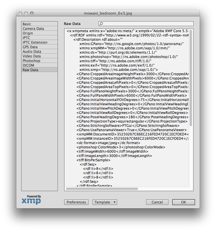
The new XMP File Info window in Photoshop CC 2014
Step 5. All thats left is to add your Equirectangular image to your photos in Google+ [updated 14-12-15 to reflect the demise of Google Map Views]
UPDATE 14/11/2015: Adding a Photosphere to Google Maps
In early June 2015 Google shuttered Google Map Views and inadvertently plunged us into quite a different world of publishing photospheres. There were a number of areas in which methods of publishing and accessing photospheres were lost or severely changed.
- The ability to build Constellations has disappeared, and it's return date is unknown
- Locating photosphere based solely on their longitude and latitude is no longer possible. Photosphere now have to be attached to a map marker
- Descriptions from photospheres pre shuttering cannot be seen and new ones cannot be created
- Embedding photospheres is no longer possible
Tony
